
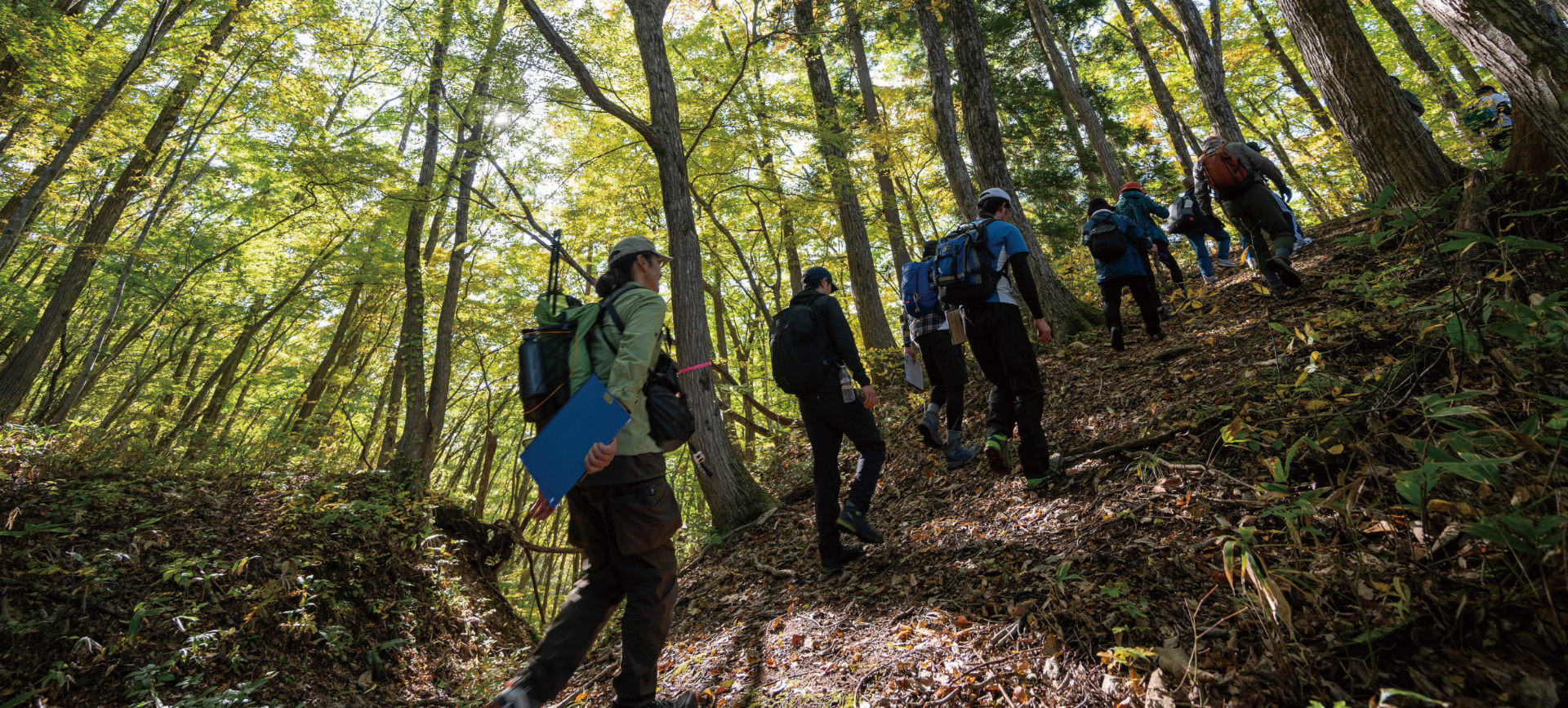
A "walking trip" where you can feel Aizu slowly and get to know it carefully
Aizu TrailAbout the Aizu Trail
The Aizu region, which extends to the western part of Fukushima Prefecture, is blessed with abundant nature such as vast forests, varied mountains and rivers, and rare flora and fauna. In addition, in rural areas, the scenery of satoyama, which is a combination of nature and people's lives, remains. The "Aizu Trail" connects the "roads" where you can feel the nature and unique culture of Aizu and the warm hospitality of the people who live there, such as quaint village roads, satoyama roads with rural scenery, and former highways. I'm out. Please feel the rich Aizu with your skin at walking speed.
Walk the Aizu trailWalking the Aizu Trail
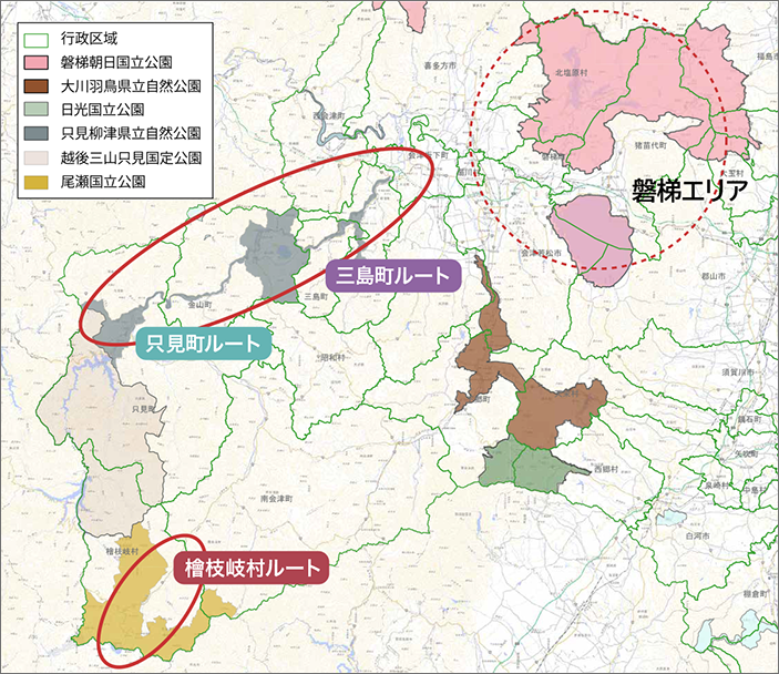
Hinoemata Village RouteOze / Hinoemata area
A trip around the traditions of the mountains and the nature of Oze
Tadami Town RouteTadami Yanaizu area
A "walking trip" over the scenery of the water source forest and village
Mishima Town RouteTadami Yanaizu area
A trip around the scenery of the paulownia village and the river
Hinoemata Village Route
Experience the tradition of mountain people rooted in Hinoemata and enjoy the vast scenery of the Oze marsh and mountains across the pass
Basic information on the Hinoemata Village route
Distance of the entire route: Approximately 13.8km
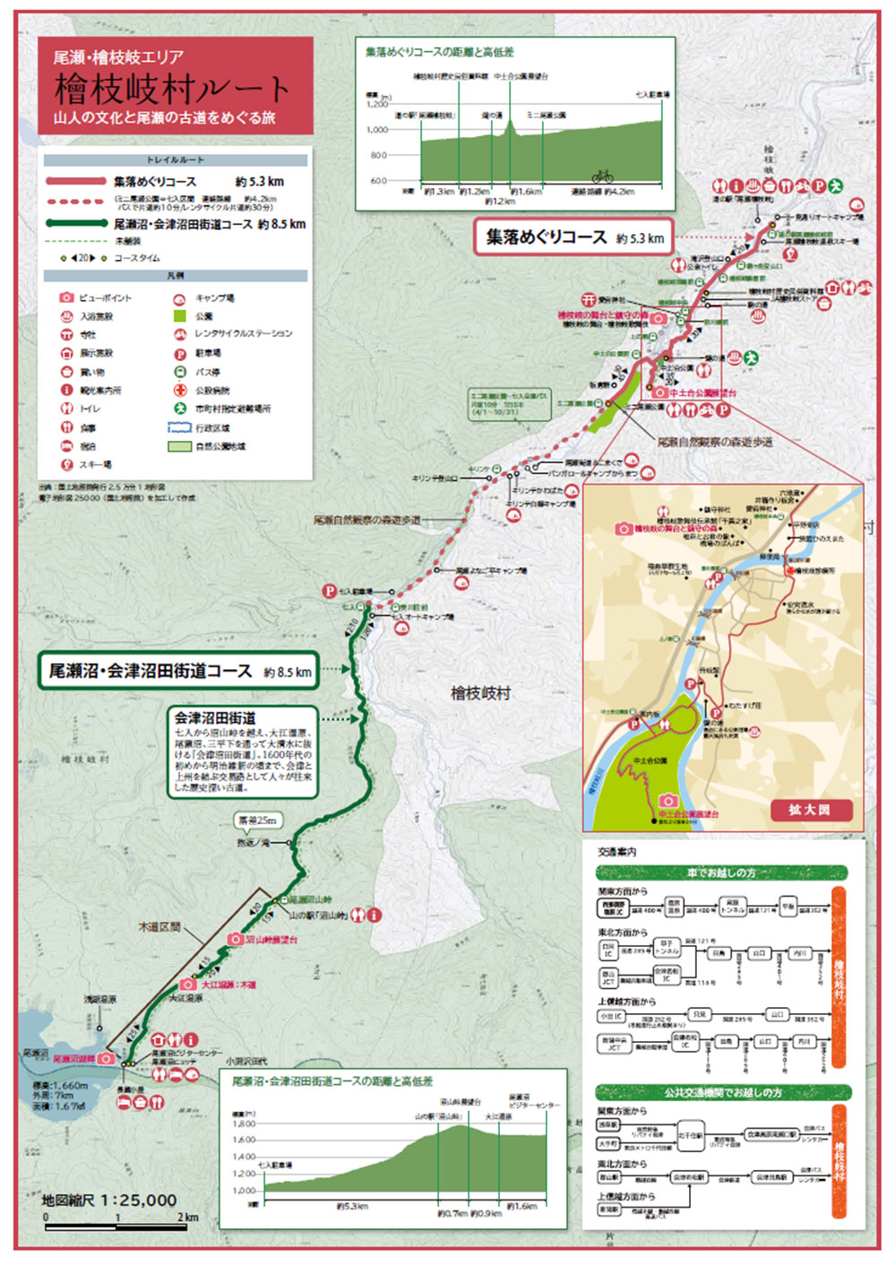
Village tour course (about 5.3km, one way about 2 hours and 30 minutes)
| The gateway to Oze National Park. A course to learn about the unique wisdom and culture of Yamamura, who has lived with the harsh nature, such as the Kabuki stage of the guardian forest, and to explore the appearance of the village. |
| Difficulty ★ (for the general public) |
| Nearest transportation / parking lot Road Station "Oze Hinoemata" Parking Lot / Bus Stop Mini Oze Park Parking Lot / Bus Stop |
Ozenuma / Aizu Numata Highway Course (approx. 8.5km / one-way approx. 4 hours)
| A mountain climbing course where you can enjoy the vast scenery of Ozenuma and the surrounding deep mountains while walking along the wooden path of the Oe Marsh, crossing the Numayama Pass on the former highway where the natural road remains. |
| Difficulty ★★ (for beginner to intermediate climbers) |
| Nearest transportation / parking lot Nanairi parking lot / bus stop |
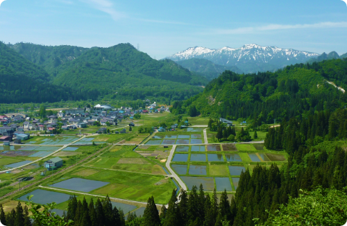
Hinoemata Village is the gateway to the Fukushima Prefecture side of Oze National Park, located at the southwestern tip of the Aizu region. Surrounded by 2000m-class mountains such as Hiuchigatake and Aizu Komagatake, the highest peaks in Tohoku, the altitude of the village exceeds 900m. Due to the lack of flat land and short daylight hours, rice could not be grown, and until the 1955's, the family lived in a "dezukuri hut" built near the fields and raised buckwheat. Hinoemata Kabuki was dedicated to the god of protection by gathering people in May when they went out to the hut and in August when they returned to the village to pray for a good harvest and thank them for their reunion. The skills and spirit of Kabuki, which are all supported by the villagers, have been passed down from parent to child for generations and convey the lifestyle of the village.
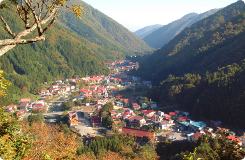
Hinoemata Village nestled in Yamafutokoro
From the Nakadoai Park Observatory Overlooking the village nestled in the deep mountains.
The roof painted in red rust is beautiful.
Aizu Numata Highway
An old road connecting Aizu and Joshu, which was once used as a trade route.
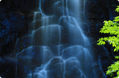
From Nanairi to Numayama Pass,
There are still natural roads along the river.
The dakigaeri waterfall on the way has an elegant look.

Oe Marsh
The largest marshland around Ozenuma.
Wetland plants show seasonal expressions.
It is also the headwaters of the Tadami River, which runs through the Aizu Trail "Tadami Yanaizu Area".
Contact for this route
Oze Hinoemata Onsen Tourism Association
Yubinbango967-0527 Fukushima Prefecture minamiaizu district Hinoemata Village shaped outlook 1155-1
TEL.0241-75-2432 / FAX.0241-72-8010
Tadami Town Route
See the huge dam, feel the deep forests of the water source, and learn about the history of the people of the town who have lived with nature.
Basic information on the Tadami Town route
Distance of the entire route: Approximately 15.3km
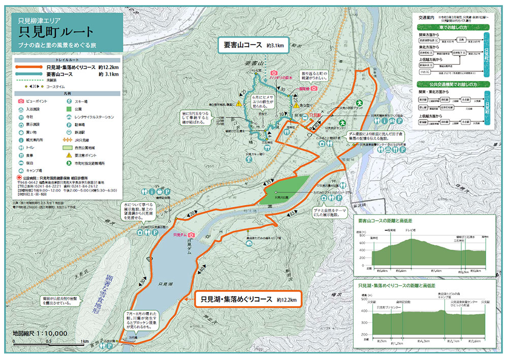
Hazardous mountain course (about 3.1km, about 2 hours)
| A short but steep mountain road. Looking back, the view of the expanding village is a reward. A mountain climbing course where you can experience the unique mountain scenery of Tadami, such as thin ridges carved by heavy snowfall and large beech trees. |
| Difficulty ★★ (for beginner to intermediate climbers) |
| Nearest transportation / parking lot Tadami Station, Tadami Town Tourism Town Development Association Parking Lot |
Tadami Lake / Village Tour Course (approx. 12.2km / approx. 3 hours 30 minutes)
| Take a tour of the green and water villages blessed with abundant forests and pure water that have been certified as UNESCO Eco Parks. Look out over the huge dam and stop by the exhibition facilities to learn about the history and nature of the town. |
| Difficulty ★ (for the general public) |
| Nearest transportation / parking lot Tadami Station, Tadami Town Tourism Town Development Association Parking Lot |
Tadami Town is located at the western end of the Aizu region, on the prefectural border with Niigata Prefecture. Surrounded by mountains at an altitude of 1,000 m, villages are gathered along the Tadami and Ina rivers, which originate from Oze. In the mountains, there are virgin beech forests, broad-leaved forests such as Quercus crispula and horse chestnut, and in autumn, the leaves turn bright and bear nuts, nurturing the lives of many organisms. winter. Deep snow scrapes the surface of the mountain and makes the mountain steep, but it becomes nutritious water and flows through the river, and from spring it grows delicious rice and vegetables in the village. After the war, "Tagokura Dam" and "Tadami Dam" were constructed using abundant water. The contrast between the rich nature and the artificial lake is also a charm of the town.
Tadami UNESCO Eco Park
Registered in 2014.
"Snow erosion terrain", "mosaic vegetation", etc.
The characteristic natural environment created by heavy snowfall
We continue to protect the culture nurtured in it.
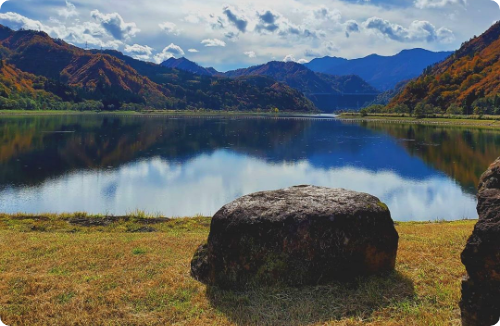
Lake Oku-tadami
The Tadami Dam uses a head of about 20m from Lake Tadami to generate electricity by flowing water at 375 cubic meters / second.
Lure fishing is also popular at Lake Tadami.
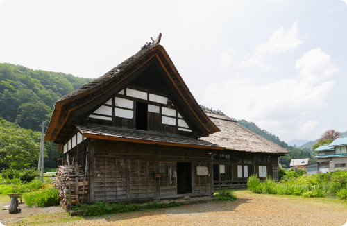
Kanozu Bansho (former Hasebe family residence)
Built in the late Edo period. It was used as a guard station for "Yarikoshi" that connects Aizu and Echigo. Prefectural important cultural property.
Contact for this route
Tadami Town Tourism Town Development Association
1791-6 Uenohara, Tadami Town, Tadami- cho, Minamiaizu-gun, Fukushima 968-0421
TEL.0241-82-5250 / FAX.0241-82-5810
Mishima Town Route
See the scenery of the Tadami River and the bridge, and learn about the nature of Satoyama and the lifestyle rooted in it.
Basic information on Mishima Town route
Distance of the entire route: Approximately 16.5km
Mishima Town/ Numata Highway Course (about 5.2km, about 3 hours one way)
| After taking a bird's-eye view of the No. 1 Tadami River Bridge, which is popular with railroad fans, we will visit the old road that the patrol messenger also walked. A hiking course where you can enjoy the history and rich nature of Mishima Town. |
| Difficulty ★★ (for beginner to intermediate climbers) |
| Nearest transportation / parking lot Aizu Miyashita Station, Mishima Town Tourism Association Parking Lot |
Village tour course (about 11.3km, about 3 hours and 30 minutes)
| A course around "the most beautiful village in Japan". Starting from Aizu-Miyashita Station, we will visit the appearance of a small group of villages while looking at the water surface of the Tadami River up close. You can also see the seasonal changes. |
| Difficulty ★ (for the general public) |
| Nearest transportation / parking lot Aizu Miyashita Station, Mishima Town Tourism Association Parking Lot |
Mishima Town is located in the midwestern part of the Aizu region, and is a mountain town with villages scattered along the Tadami River, which originates from Oze. The JR Tadami Line runs along the Tadami River, creating seasonal scenery alongside the nature of the valley and the lifestyle of the village. In heavy snowfall areas where snowfall can exceed two meters in winter, the technique of making baskets and other folk implements using materials from Noyama has been handed down as a handicraft in winter. It is also the production center of "Aizu paulownia", and in the spring, light purple flowers bloom in various parts of the town. A town that has preserved a culture that is in harmony with nature, such as making folk implements and folk events such as "Mishima's Sinokami," is also a member of the "Japan's Most Beautiful Villages" Union.
Scenery of Tadami River and No. 1 Tadami River Bridge
The Tadami River, which runs through the town, has three bridges on the JR Tadami Line, which creates a unique and beautiful landscape in combination with the nature along the river and the appearance of the village.
Mishima Sinokami
Every year on January 15th, the Fire Festival of the First Full Moon Festival is held to pray for a good harvest, no illness, and apotropaic magic.
Kamiki is lit in each district of the town.
A nationally designated important intangible folk cultural property.
Okuaizu braid work
Making folk implements that have been passed down from ancient times.
The materials are Hiroro and Actinidia polygama,
The blessings of wild mountains such as the vines of mountain grapes.
It is designated as a national traditional craft.
Contact for this route
Mishima Town Tourism Association
In "Karakon", 214-5 Miyashita, Oaza Miyashita, Mishima Town, Onuma-gun, Fukushima 969-7511
TEL.0241-48-5000 / FAX.0241-42-7072